Skip to content

An exceptional Gallo-Roman site in the heart of the Millevaches Plateau

The Millevaches Plateau

The archeological site of Les Cars is located in the heart of the Millevaches Plateau, in the New Aquitaine region. We are at the foot of the Massif Central. The average altitude is 800 metres ; the highest point is Mount Bessou which rises to 977 metres. This plateau is a succession of glens without deep valley.

An archaeological site discovered by chance

The site was excavated as early as 1917 by Marius Vazeilles However, it was not until the 1930s that archaeological excavations began.

Marius Vazeilles was a forest ranger (1917- Book – "La mise en valeur du plateau de Millevaches"). While studying the human settlement that impacts the landscape around Saint-Merd-Les-Oussines, he is intrigued by a huge granite tank of more than 6 cubic meters partially buried at the bottom of a valley.

The exploration of the surroundings enabled to identify the platform of the tomb-temple thanks to the outcropping granite blocks. The ruins of Cars turn out to be those of a major archaeological site. Marius Vazeilles Then, he manages to obtain funding to launch archaeological excavations and involves the local population in the adventure. He excavated the most obvious elements, inventoried the objects, established the first hypotheses and and founded in 1935,a museum that can be visited, 25 km from the site. The Marius Vazeilles Museum is located in the magnificent abbey of Saint-André in Meymac, where you can also visit a Contemporary Arts Center .

The place name "Millevaches"

The place name Millevaches , according to different hypotheses, comes from « thousand springs » (mille batz) or from the « empty mountain » (mello vaca).

  • « Milles sources » (mille batz / meaning "thousand springs") but there's no evidence to validate this term
  • The association of a Gallic word, mélo which designates a height, a mountain, and a Latin adjective, vacua, which means empty, abandoned in the sense of peeled (because of significant deforestation). This term is found in Occitan Miuvachas which implies the same meaning. It was the switch to French that gave Millevaches

The traditional landscape is moorland and heath  (some can still be seen behind the parking lot at the level of the GR -> Grande Randonnée = Great Hike) and peatbogs that were used as grazing fields for sheep. It was also the only means of heating for the inhabitants. The forest and meadow landscape is more recent (after 1945)..

Logo tampon Bac des Cars

... And what does the name "Les Cars" mean?

The site of Les Cars is dubbed « le Bac des Cars » by the inhabitants. Indeed, the granite cistern in the lower site is the emblem of the place but for a long time it was a landmark in the landscape because it was visible whereas the rest of the villa burried.  

There are also several interpretations of the word "Cars" :

  • Granite blocks, well squared, "Cars" could come from the Middle Ages : "quadris" or "cadris" ; a word that brings to mind square objects, rectangular blocks and large apparatus
  • Stone quarry (some of the surrounding houses are built with stones from the site) called quadraria. The ruins of Les Cars have long been used by the inhabitants as a stone quarry, many houses have stones from these remains (Ars-Les Maisons)
  • The river that flows near the site was called (Napoleonic cadastre) del carl…

It was the Time of the Pax Romana

Voies romaines dans l'empire. IIè siècle ap. JC
Roman Empire's routes. IInd second century AD (after JesusChrist). Author : Andrei N.

It is a Gallo-Roman site founded in the second century AD (after JesusChrist). It was the time of the Pax Romana, a time of economic prosperity both in Gaul and in the Roman Empire. The borders were practically stable except in Germania and the economic activity was intense. The villas, like the one in Les Cars, were often important farming compounds. There were many in Gaul, you could find one every ten to twenty kilometres. The Roman routes were stable too : here it pretty much follows « la route des bois » and it can be seen near Barsanges. It connected Augustoritum (Limoges) to Augustonemetum (Clermont-Ferrand) and to the Gaul's capital city Lugdunum (Lyon)You can see part of this road while driving on the touristic road named the beech road (near a small village called "Barsanges" // D979 E2)

Upper site : the funerary monuments

Two main architectural elements are visible on the upper part of the site. These two elements are distinct but they form a whole. According to the latest research, the southern monument was probably a funerary monument. 

Vue aérienne du site gallo-romain des Cars : les tombeaux
Aerial view of the funerary monuments

North monument: an individual grave and a glass cinerary urn

North monument: (next photography) is more damaged. Only the first steps are visible. However, they give an idea of the height of the podium of the building. In that space, there is a tomb with a glass cinerary urn. This tomb was placed in a 4.38m2 burial chamber. The tomb has two parts : a fixed part with the urn, and another, the lid of the vault with its pyramidal shape. Different objects that can be seen in the Marius Vazeilles museum in Meymac were found around the tomb.

Ruines Gallo romaines des Cars : les tombeaux et l'urne cinéraire
Base of the cinerary urn of the northern monument

Funeral rituals

There were funeral rituals around those urns:

  • The body of the deceased was laid on a funeral bed and people were shaking or apostrophizing the dead body to ensure he or she was dead
  • The body was burnt on a funeral pyre with items belonging to him/her
  • Bunrt body's bones and ashes were deposited in a terracotta urn for the poorest and in a glass urn for the richest and placed in the funeral chest
 

In the southern monument, the funerary chest was placed in a funerary chamber of 4.38m². The funerary chamber consists of two parts: a part enclosed in the paving in which was the urn and the lid of the chest with its particular pyramidal shape. 

Archeologists speak of funerary monuments. There were many in the Occident in the first century AD (after Jesus Christ) (in the years 60 to 100.) J’ai traduit occident par « Occident » par opposition à l’Orient j’imagine.) Even if this building resembles an ancient temple dedicated to the Gods, it seems that it had a funerary function . Two tombs (one richly decorated) were discovered. This luxurioux tomb can be seen in the chapel of Barsanges. A bas-relief representing animals and a scene of spear hunting is sculpted in the block of granite. It must have belonged to a prominent citizen. This exceptional tomb - both for its size and its sculpted decoration – was probably built in the heart of the podium. (see plans below).

Southern monument: second tomb-temple

The southern monument remains the most visible and the best preserved. According to the latest research, its functions would surely be those of a temple-tomb.

Plan de la partie sanctuaire du site gallo-romain des Cars
Plan of the sanctuary part of the Gallo-Roman site of Les Cars. Interpretation based on the work of Guy Lintz. Saint-Merd-Les-Oussines - Corrèze - New Aquitaine

A temple-tomb composed of a podium in the shape of an abside

Its shape is very pecular : there is a podium in the shape of an abside ((rounded like in the choir of churches).Archeologists speak of funerary monuments. There were many in the Occident in the first century AD (after Jesus Christ) (in the years 60 to 100). This building is composed of three steps , the third one has disappeared. It had columns at the entrance, some elements are still visible (shafts, capitals, bases).[1]. But most of all, they found a richly decorated funerary chest which could not have been intended to be buried.

[1] Philippe Leveau, Mme Isa Odenhardt-Donvez, Isabelle Fauduet, Aix-les-Bains et son tombeau-temple : «ruralité» et «urbanité» d’un vicus allobroge.

Even if this building resembles an ancient temple dedicated to the Gods, it seems that it had a funerary function . Two tombs (one richly decorated) were discovered. This luxurioux tomb can be seen in the chapel of BarsangesA bas-relief representing animals and a scene of spear hunting is sculpted in the block of granite. It must have belonged to a prominent citizen. This exceptional tomb - both for its size and its sculpted decoration – was probably built in the heart of the podium.[1].

[1] Jean-Louis PAILLET et Dominique TARDY, "The funerary monuments of the Cars."

Architecture and building techniques

The mausoleum comprises compartments/niches along the walls to receive the tombs of the less important members of the family.[1]

The blocks forming the entablature are still visible, mainly the cornices (40 blocks). But on the side, the walls were probably solid walls adorned with pilasters. The estimated height of the monument is 4m72.

The roof was made from very heavy granite plates. (They can be seen when we look towards Les Maisons, they are in fact arranged vertically.) Given the weight of the plates, the building could not be open. The length and width of the plates reached 2.96m and 1.23m respectively. Some plates had notches probably to fit into one another.

[1] Jean-Louis PAILLET et Dominique TARDY, "Monumental funerary architecture, Gaul in the Roman Empire". ,2006.

Techniques de construction : décor architectural du mausolée
Building techniques: architectural decoration of the mausoleum. Bac des Cars - The tombs - Gallo-Roman archaeological site Les Cars - Saint-Merd-Les-Oussines - Corrèze - New Aquitaine. Based on the work of Jean-Louis Paillet and Marie-Christine Monguillan

Construction techniques

The blocks were sealed to one another with lead clips that fitted into holes.. Those holes called "Trous de louve" where used to lift granite blocks.

These construction techniques are presented on the technical data sheet available on the site.

The villa and the "Bac des Cars"

Plan de la villa du site archéologique des Cars.
Plan of the villa of the Cars archaeological site. From the sketches of Marius_Vazeilles (Booklet "Gallo-Roman station of Cars" - Page 21 - 1962). Saint-Merd-Les-Oussines - Corrèze - New Aquitaine

A Villa focused on the water resource

Below, we can see the remainsof a 16-room villa. The villa is designed in open plan : the atrium is not en enclosed space so that the villa faced a pond created thanks to a dike. The villa consists of two parts : in a first construction phase, the cistern dominates (A) This cistern is very impresssive : it was carved in a monolithic block of stone, weighing 8.5 tons..  And a second construction phase around the dining room : the triclinum. (15).

The first part is composed of at least six rooms heated by hypocaust (an under-floor heating system) (rooms 1 to 7). The cistern (A) supplied the villa in running water. The water pipes – some of which have been found - were made of wood. (we found some preserved in the bog) and granite ( w you can see granite pipes all around the villa). The water probably circulated in a continuous flow. The hypocaust heating was to supply a bath, (It was private baths)The under-floor heating heated the water that circulated on the floor. (a & b) In the back of the house, a fireplace heated the rooms as well as the swimming-pool. Ceramic dating enables us to estimate the construction date between the years 125 and 150 AD (after Jesus Christ).

Most probably, there was a caldarium (hot room), a tepidarium (warm room) and a frigidarium (cold room), a swimming pool (1) and farther away, the latrine. 

Système d'hypocauste (chauffage des thermes romaines)
Hypocaust system (heating of Roman baths). General view. Saint-Merd-Les-Oussines - Corrèze - New Aquitaine.
Système d'hypocauste : tubuli et pilettes. Vue 3D

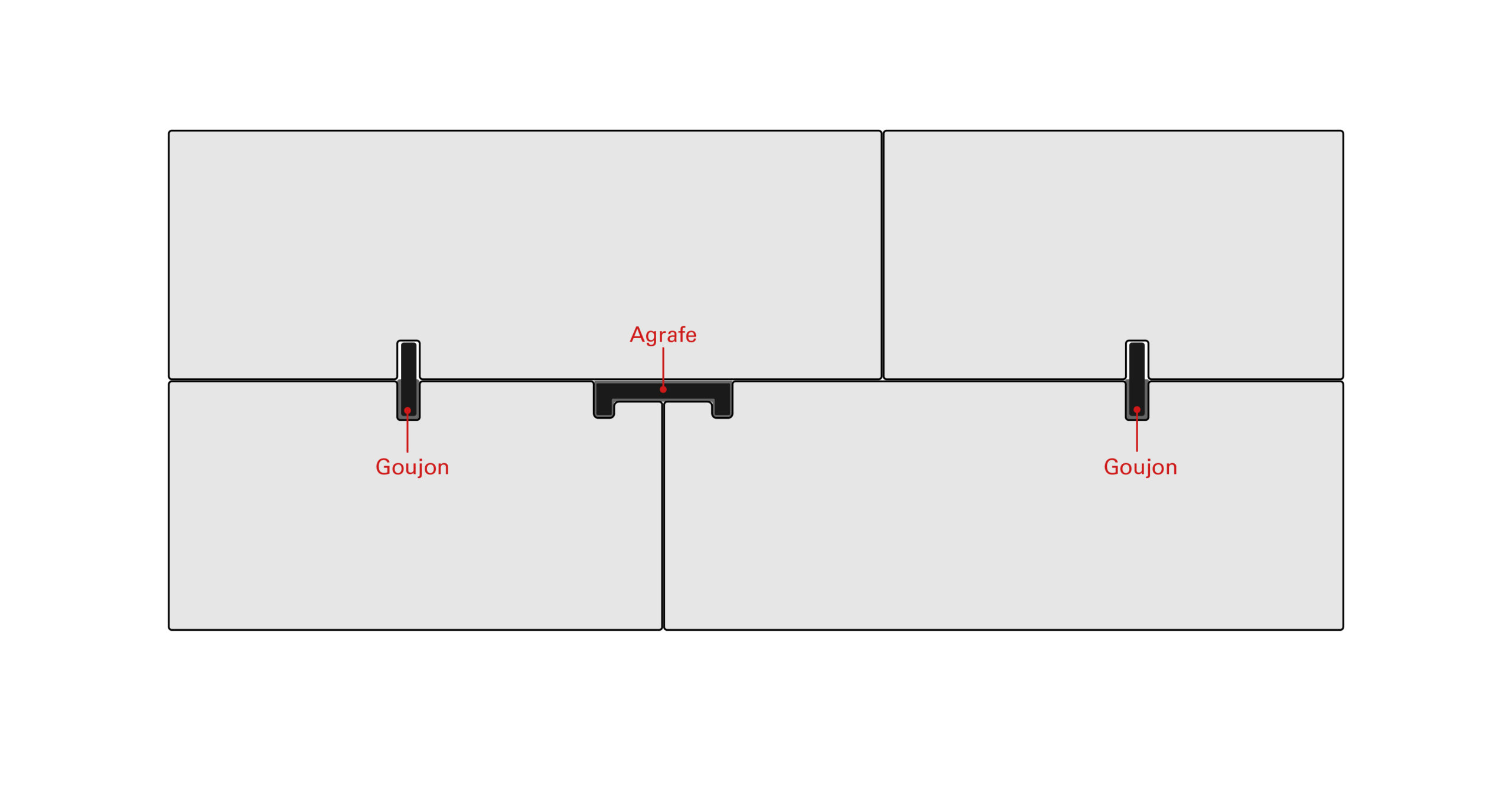
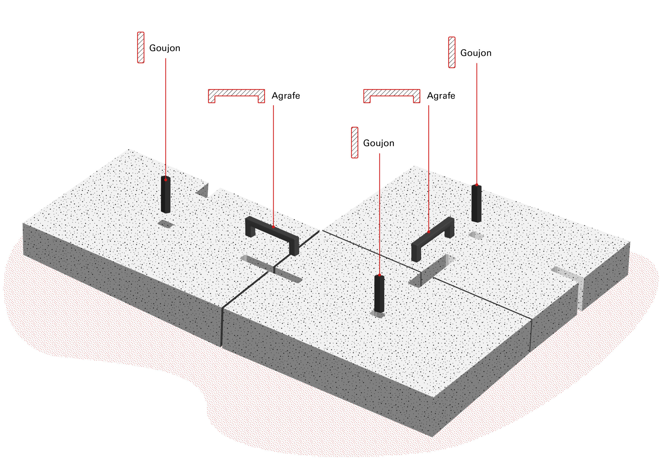
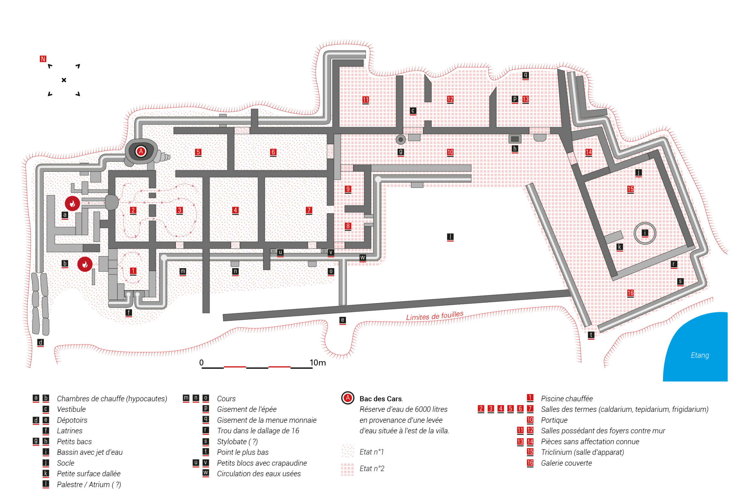
Pilettes and tubulis

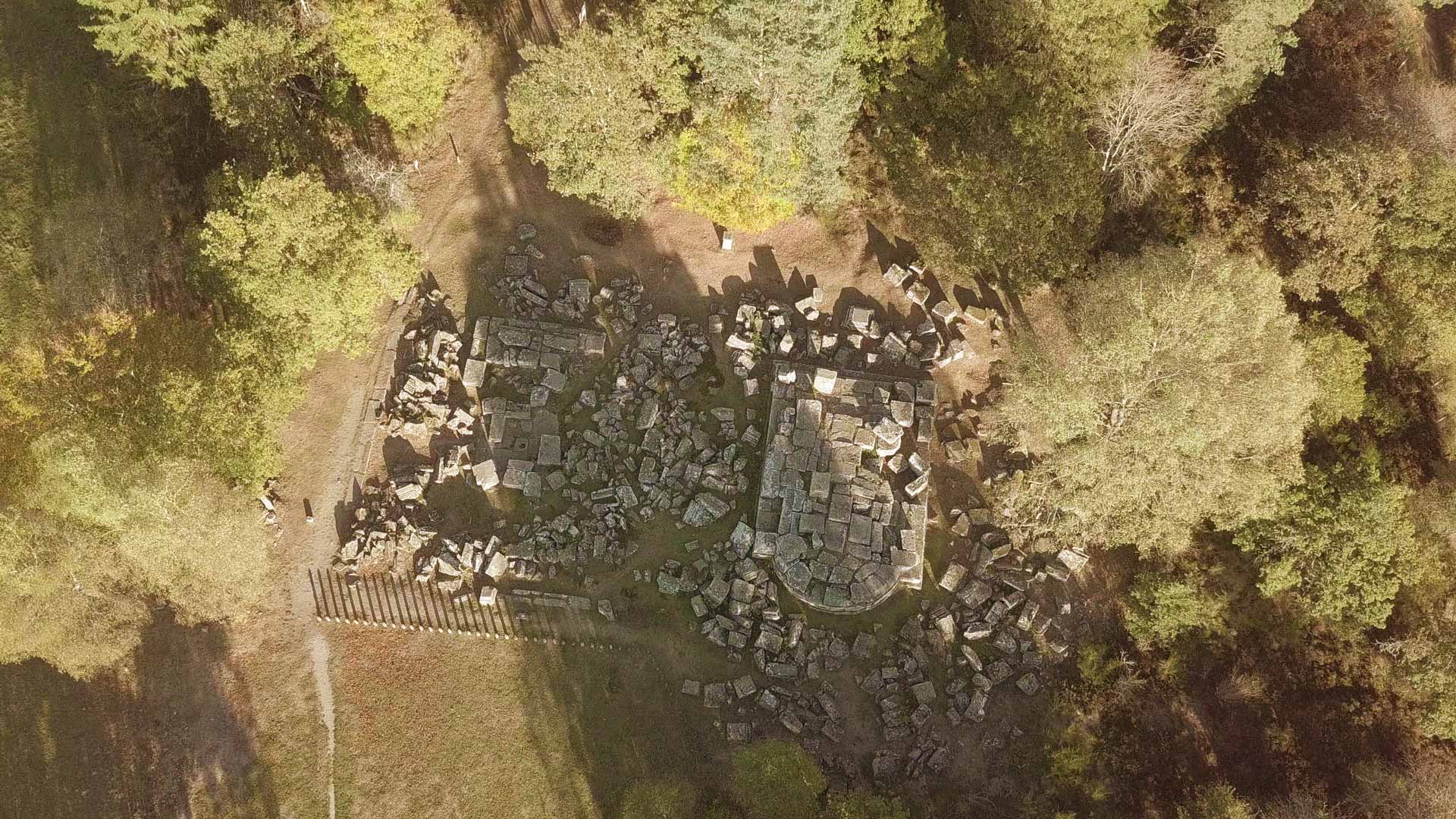
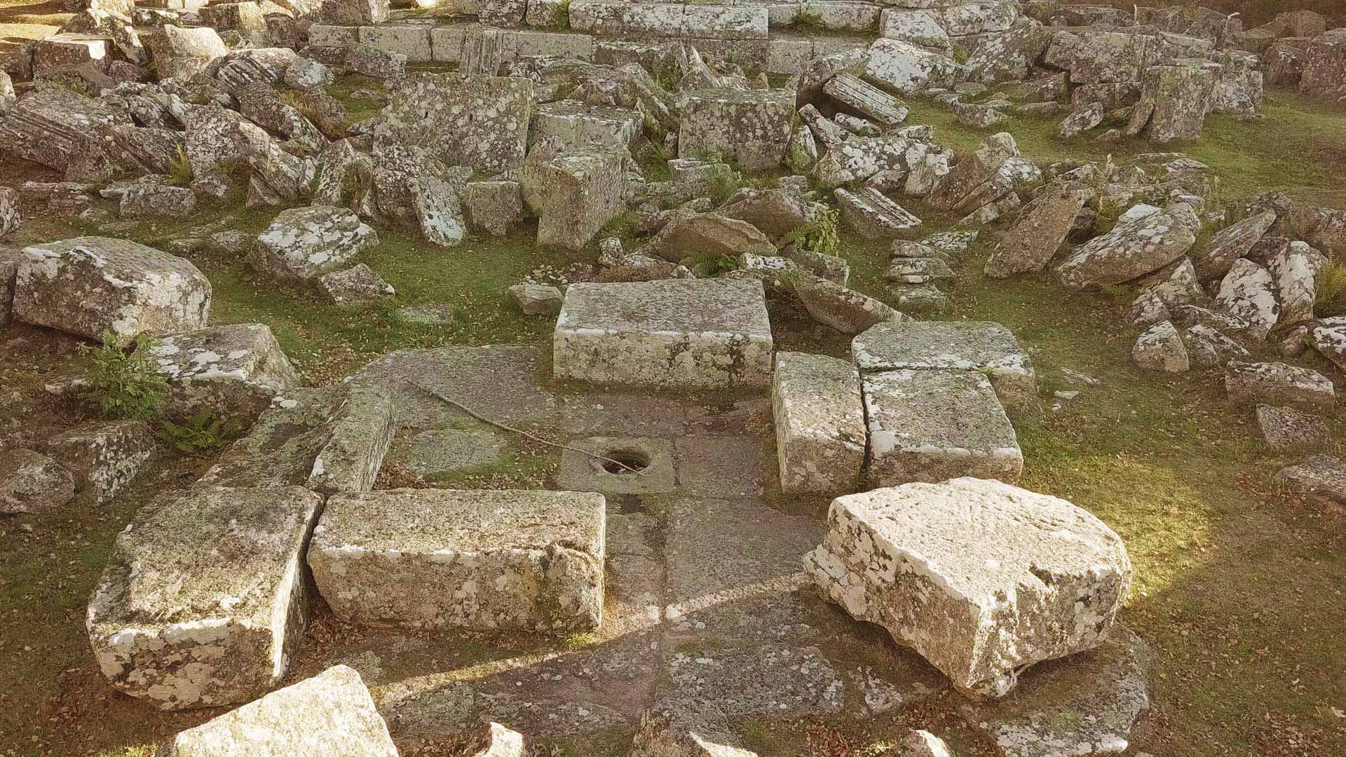
Hot air of the terms was running within an ingenious system of double walls and double floors
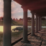
A luxurious villa!

The second part of the villa is dated between the last 2ndcentury and the begining of the 3rdnd century. The villa is organized around the atrium (l)and the open courtyard is flanked by a portico (16).

The rooms against the supporting wall were more traditional : a kitchen with a fireplace and bedrooms. (11 & 12) We can notice that the wall was built in opus spicatum or in « a herring bone pattern ».This construction technique enables to stand higher constraints.

In one of the back rooms (13) , some objects were found : weapons dating back to the end of the third century, probably the date when the site was abondonned.

The last room (15) was not aligned but looks out to the former pond. This room, the triclinium (dining room) faced west. In this triclinium a grey and red sandstone fresco was found. (sandstone from Collonge-la-Rouge) and grey (Slates from Brive) A lead water pipe that filled a basin, marble fragments and painted plaster were also found, evidence that the room was brightly coloured. The notches that allowed the doors to open outwards are still visible. And outside this room, there is a large terrace with a view on the pond and the setting sun. 

The construction of the second part of the villa dates back to the end of the second century or the beginning of the third century. There was probably a village around this villa : several hut dirt floors were identified and ancient coins were found. From the villa, the inhabitants could see the two mausoleums.

The first construction phase of the villa must coincide with the first monument.

The 3D reconstruction film of the Gallo-Roman site of Les Cars was financed by: fondation EDF, Conseil Régional du Limousin, Direction des Affaires Culturelles (DRAC) du Limousin andUnion Européenne (Fonds FEDER).
With the help of IRAA-CNRS
Scientific Direction: Dominique Tardy, Jean-Louis Paillet (IRAA – CNRS), Régis Delubac (ABF/STAP Corrèze), Raphaël Gestreau (SRA-DRAC Limousin) et Patrice Montzamir (CD19)
3D Design: Court-jus production
Production and 3D artistic direction: David Geoffroy
3D modeling graphic designers: Xavier Carton, Mathieu Ciavarella, Alexis Jouanneaux
Production Assistant: Vanessa Gonçalves
Special thanks to: musée Marius Vazeilles de Meymac, Michel Escurat (CD19) et Guy Lintz (Archéologue)

Reconstitution 3D de la villa : vue depuis la terrasse du triclinium sur l'étang orienté Ouest

Complete movie:

Movie available on the Youtube channel of the Departmental Council of Corrèze.

Logo tampon Bac des Cars

Marius Vazeilles, a visionary scholar

1881 – 1973

Marius Vazeilles was a curious and smart forest ranger. That's why he suspected soon that the big granite cistern he saw down the peatbogs should deserve more attention. He had the idea of digging around. With the help of the inhabitants, he searched the ruins and obtained the necessary funding to start archeological digs. It was also Marius Vazeilles who, as early as 1920, encouraged the small farmers to plant the forest as we can see it nowadays. He thought the forest combined with farming. It enabled the farmers to have an additional income by planting the parts less favorable for cattle breeding.

Eventually he became an archaeologist!

Most obvious objects found on the site can be seen at the Marius Vazeilles museum in Meymac, 25 km from the site. Contemporary Arts Center The museum is located next to the Saint-André abbey and the contemporary art center.

en_GB